

Maxar Technologies
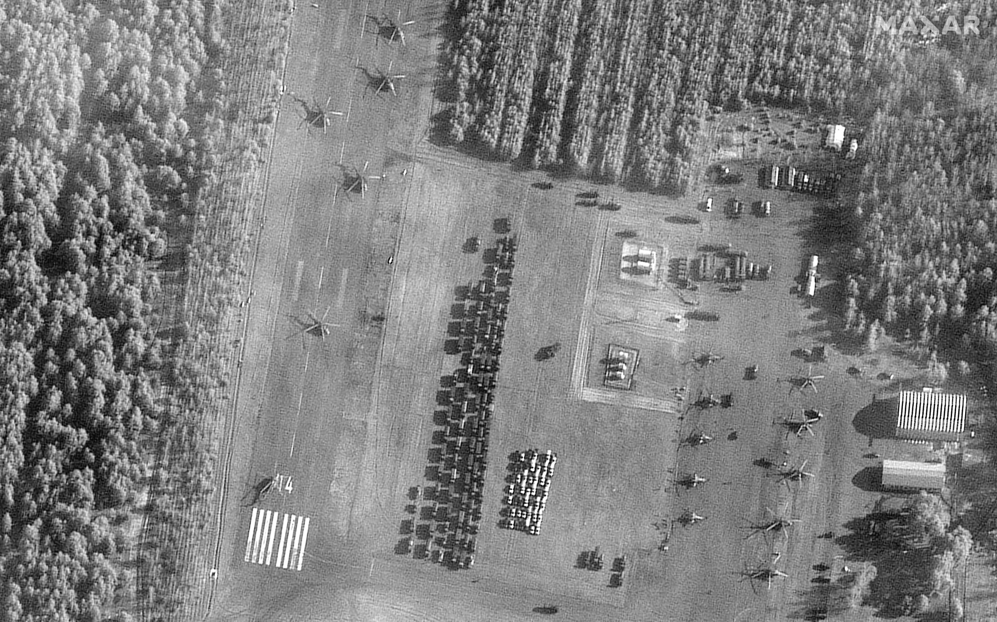
Update, 10 am ET, 3/1/2022: On Tuesday, Mykhailo Fedorov, the vice prime minister and minister of digital transformation of Ukraine, confirmed that his country is seeking the cooperation of commercial satellite operators. The goal is to obtain data, particularly from synthetic aperture radar, about the movement of Russian vehicles so that Ukrainian forces can respond.
“We badly need the opportunity to watch the movement of Russian troops, especially at night when our technologies are blind in fact! SAR satellite data is important to understanding Russian troop and vehicles movements at night considering that clouds cover about 80 percent of Ukraine during the day,” Fedorov wrote in a letter that he posted on Twiter.
@eos_da and @maxpolyakov appeal to the global remote sensing firms and organizations to provide real-time SAR data to support the Armed Forces of Ukraine with actionable intelligence. pic.twitter.com/DzfNze3K3r
— Mykhailo Fedorov (@FedorovMykhailo) March 1, 2022
Ukrainian entrepreneur Max Polyakov made the initial request on Monday night with an urgent plea saying, “We need the data now.” His company, EOS Data Analytics, is offering to quickly analyze and process the data for use by the Ukrainian Defense Service. The company has set up a webpage here with more information.
Original post: Ukrainian entrepreneur Max Polyakov was emotional—and at times angry—during a 20-minute call with reporters on Monday evening as he spoke about the attack by the Russian military on his homeland.
“Within one hour, there will be an attack on Kyiv again,” Polyakov said, pointing emphatically to his watch. “We need the data now.”
The data he referred to was real-time observations made by commercial satellites flying over Ukraine. Polyakov pleaded with the operators of these satellites, primarily Western-based companies who sell data to governments and private customers, to freely share their data with one of his companies, EOS Data Analytics.
Polyakov said EOS would rapidly process this data for passes over Ukraine and provide some basic analytics before sending the information to the Ukrainian Defense Service and the Ministry of Digital Transformation. EOS has the capability to quickly differentiate between 18 different types of Russian military vehicle, he said.
“Right now, we need to have this intelligence,” he said. “Every night, we’ve been bombarded, and at night we are blind. We need this data, please.”
Polyakov noted that in recent days, commercial companies have been releasing high-resolution satellite imagery into the public domain to showcase their capabilities. While this has been impressive, he acknowledged, such releases have been more useful for public relations purposes than for giving actionable information to the Ukrainian military. The data is often two or three days old, Polyakov said. “We don’t need to know where Russian tanks were two days ago,” he said.
He also cited the need for a special kind of intelligence that has become increasingly popular in recent years: data from synthetic aperture radar, or SAR, satellites. In contrast to passive optical satellites that collect data in the visible, near-infrared, and short-wave infrared portions of the spectrum, these satellites emit their own energy. They then record the energy reflected back from the surface of Earth.
The key advantage of SAR satellites is that they can collect data during the day and at night and through cloud cover. Polyakov said SAR satellite data is important to understanding Russian troop and vehicle movements at night and noted that clouds cover about 80 percent of Ukraine during the day.
Noosphere/Zoom
Polyakov is appealing to Planet Labs, Maxar Technologies, Airbus, SI Imaging Services, SpaceView, BlackSky, Iceye, Capella, and other companies that can provide the needed data.
During the call with reporters, Polyakov acknowledged that he was making an “aggressive” request. The 44-year-old entrepreneur has a checkered relationship with US regulators and was recently—and to some observers, unfairly—forced to sell his controlling interest in the US-based launch company Firefly. However, the passion he clearly feels about preserving his homeland is difficult to deny.
It is not immediately clear how commercial companies will respond. This is the first major war in which commercially available satellite imagery has played a significant role in providing open source information about troop movements, military buildups in neighboring countries, flows of refugees, and more.
Previously, such data was proprietary and largely collected by a handful of nations. The role of such a powerful, widely available technology has yet to be defined in a warfighting domain, and it’s not clear whether private companies are willing to freely hand over raw data to another commercial company with the intent of helping one side in the conflict.
But we’re about to find out.